India-Pakistan Water Strategy and Pakistan’s Growing Concerns- Article 2
How Geography, History and Water Politics Are Reshaping the Future of the Indus Basin
India-Pakistan Water Strategy and Pakistan’s Growing Concerns. “Control over the source of a river has often meant influence over the destiny of civilisations downstream.”
https://mrpo.pk/water-power-and-survival/

Water has always flowed according to the laws of nature. Yet throughout history, nations have sought to shape, regulate and harness rivers to secure food, generate electricity, prevent floods and strengthen economic development. In the twenty-first century, however, rivers have acquired another dimension. They have become instruments of strategic planning, diplomatic engagement and, at times, geopolitical competition.
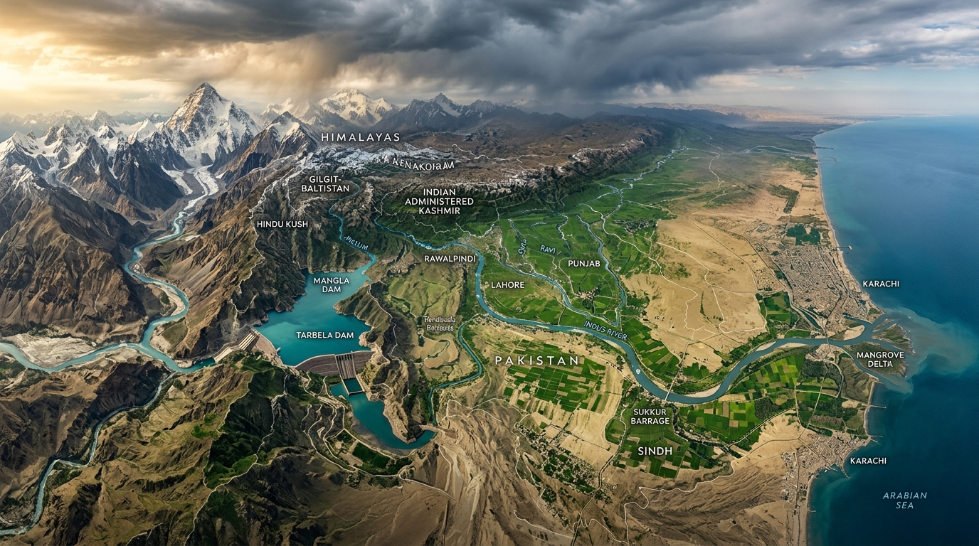
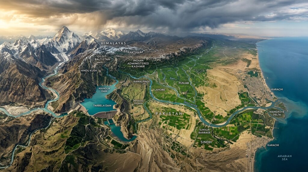
Few river systems illustrate this reality more clearly than the Indus Basin. Stretching from the glaciers of the Himalaya, Karakoram and Hindu Kush to the Arabian Sea, the basin supports hundreds of millions of people across China, India, Pakistan and Afghanistan. It sustains agriculture, powers industries, generates electricity and supports ecosystems that have nurtured civilisations for thousands of years.
For Pakistan, the Indus Basin is not simply an environmental resource. It is the country’s principal freshwater lifeline. Any significant alteration in the quantity, timing or quality of water reaching Pakistan has implications for agriculture, energy generation, food security, public health and long-term economic resilience.
For India, the rivers of the Indus Basin are also of strategic importance. The country’s northern states require irrigation, flood control and increasing supplies of renewable electricity. Hydropower has become a central component of India’s clean energy transition, particularly in the Himalayan region.
This shared dependence on one interconnected river system has made cooperation indispensable while simultaneously creating one of the world’s most closely watched transboundary water relationships.
This article examines the geography, history, engineering, diplomacy and international law that underpin the Indus Basin. It also explores why disagreements continue despite the existence of one of the world’s longest surviving international water agreements.
The Geography That Shapes South Asia’s Water Future
Unlike many international rivers, the Indus Basin is largely dependent upon snow and glacier melt originating in some of the highest mountain ranges on Earth.
Often described by scientists as the “Third Pole” because of the vast quantity of ice stored outside the Arctic and Antarctica, the Himalaya, Karakoram and Hindu Kush collectively feed several of Asia’s major rivers, including the Indus, Ganges, Brahmaputra, Mekong, Yangtze and Yellow River.
The Indus River begins near Lake Manasarovar on the Tibetan Plateau before flowing northwest into the mountainous regions of Ladakh. It then enters Gilgit-Baltistan, traverses the length of Pakistan and ultimately empties into the Arabian Sea near Karachi. Its major tributaries include the Jhelum, Chenab, Ravi, Beas and Sutlej rivers. Together, these rivers form one of the largest integrated irrigation systems ever constructed by humanity.
The basin supports nearly every aspect of Pakistan’s economy. Agriculture depends upon seasonal river flows to irrigate wheat, rice, cotton, sugarcane, fruits and vegetables. Hydroelectric dams generate significant portions of the country’s renewable electricity. Urban centres rely upon river water for municipal supply while industries depend upon reliable water availability throughout the year.
This geographical reality explains why Pakistan often describes water as an issue of national security rather than merely environmental management.
Understanding the Upstream and Downstream Relationship
One of the most fundamental concepts in international water management is the distinction between upstream and downstream states.
An upstream country occupies the higher reaches of a river where water originates or first enters its territory.
A downstream country depends upon water flowing from upstream territories before reaching its own borders.
This relationship creates both opportunities and responsibilities.
Upstream countries possess geographical advantages because they can develop reservoirs, hydropower projects and irrigation systems before water reaches downstream neighbours.
Downstream countries depend upon predictable river flows and therefore seek legal assurances that upstream development will not significantly reduce water availability or cause avoidable harm.
International water law attempts to balance these competing interests by recognising that neither upstream nor downstream countries possess unlimited rights over shared rivers.
Instead, modern legal principles emphasise equitable utilisation, prevention of significant harm, cooperation, transparency and peaceful dispute resolution.
These principles form the foundation upon which later treaties, including the Indus Waters Treaty, have been interpreted.
The Partition That Changed the Rivers
When British India was partitioned in 1947, political boundaries changed overnight.
The rivers themselves did not.
The new international border divided one of the world’s largest irrigation networks between two newly independent states.
Many of the headworks controlling canal systems remained inside India while large areas dependent upon those canals became part of Pakistan.
This created immediate uncertainty regarding future water supplies.
In April 1948, India temporarily suspended water flowing through certain canals serving Pakistan until an interim agreement was reached. Although supplies were later restored following negotiations, the incident demonstrated how deeply interconnected and politically sensitive the river system had become.
For Pakistan, the episode reinforced concerns regarding dependence upon infrastructure located upstream.
For India, it highlighted the need for a long-term framework capable of governing shared rivers between two sovereign states.
The search for such a framework would eventually lead to one of the most significant water agreements in modern history.
The World Bank Steps In
Recognising that prolonged disagreement threatened agricultural production, regional stability and economic development, the World Bank offered its good offices to facilitate negotiations.
What followed was not a short diplomatic exercise.
Negotiations continued for nearly a decade.
Engineers, lawyers, economists, hydrologists and diplomats worked extensively to develop a framework capable of accommodating the interests of both countries.
Unlike many international river agreements based primarily upon proportional water sharing, negotiations gradually evolved towards a different approach.
Instead of dividing annual water volumes, negotiators largely divided the rivers themselves.
This engineering-based solution was considered more practical given the political circumstances of the time.
After years of technical discussions, the treaty was signed in Karachi on 19 September 1960 by Jawaharlal Nehru, Muhammad Ayub Khan and representatives of the World Bank.
More than six decades later, the agreement remains one of the world’s longest-lasting transboundary water treaties, despite periods of war, diplomatic crises and military confrontation.
Its durability has often been cited internationally as evidence that cooperation over shared rivers is possible even between adversarial neighbours.
Yet longevity has not eliminated disagreement.
Indeed, many of the most important legal and engineering disputes have emerged decades after the treaty entered into force.
Why the Indus Waters Treaty Was Revolutionary
Most international river treaties attempt to divide water.
The Indus Waters Treaty adopted a different philosophy.
It allocated primary use of the three eastern rivers, Ravi, Beas and Sutlej, to India.
The three western rivers, Indus, Jhelum and Chenab, were reserved primarily for Pakistan, while allowing India specified non-consumptive uses, including run-of-river hydropower generation, limited irrigation and certain storage within carefully defined technical parameters.
This unique arrangement reduced many immediate disputes while creating detailed engineering rules governing future infrastructure.
It also established permanent institutional mechanisms for consultation and dispute resolution.
The treaty’s architects understood that engineering questions would inevitably arise as technology evolved.
Consequently, they incorporated procedures intended to address technical disagreements before they escalated into political crises.
Those mechanisms would later become central to disputes involving Baglihar, Kishanganga, Ratle and other projects that continue to shape India-Pakistan water relations today.
The Indus Waters Treaty: The Agreement That Changed South Asia’s Water Future
“Peace is not merely the absence of war. Sometimes it is the ability to keep rivers flowing across hostile borders.”
On 19 September 1960, after nearly a decade of negotiations facilitated by the World Bank, India and Pakistan signed the Indus Waters Treaty in Karachi.
More than six decades later, it remains one of the world’s most enduring international river agreements.
Remarkably, the treaty survived the wars of 1965, 1971, and 1999, numerous military crises, diplomatic breakdowns, and prolonged periods of political tension.
For decades, it was widely cited by international scholars as evidence that technical cooperation over shared rivers could continue even when broader political relations deteriorated.
However, the treaty has also become one of the most debated international water agreements in the world because changing technology, increasing energy demands, climate change, and new hydropower projects have generated disputes that its architects could scarcely have imagined in 1960.
Why Was the Treaty Necessary?
When British India was partitioned in 1947, engineers inherited one of the world’s most sophisticated irrigation systems.
Political boundaries divided the infrastructure.
Many important canal headworks remained inside India.
Large agricultural areas supplied by those canals became part of Pakistan.
The result was immediate uncertainty.
In April 1948, water flowing through certain canals to Pakistan was temporarily interrupted before an interim agreement restored supplies.
Although the interruption was short-lived, it exposed the vulnerability of downstream dependence.
Both governments soon recognised that a permanent arrangement was essential.
The alternative was recurring political crises over every irrigation season.
A Different Kind of Water Treaty
Unlike many international agreements that divide annual river flows through percentages or quotas, the Indus Waters Treaty adopted a fundamentally different approach. Instead of dividing water volumes, it largely divided the rivers themselves. This engineering solution was considered more practical than attempting to calculate seasonal allocations every year.
The agreement assigned:
Eastern Rivers
Ravi
Beas
Sutlej
These rivers were allocated primarily for India’s unrestricted use, subject to certain transitional arrangements.
Western Rivers
Indus
Jhelum
Chenab
These rivers were reserved primarily for Pakistan.
However, the treaty did not prohibit India from using these western rivers.
Instead, it carefully defined what kinds of uses would be permitted.
Understanding these permitted uses is the key to understanding nearly every subsequent dispute.
India’s Rights Under the Treaty
One of the most common misconceptions is that India has no rights over the western rivers. This is incorrect.
The treaty explicitly recognises several categories of Indian use. These include:
Domestic Use
India may use water from the western rivers for drinking, sanitation, municipal supply, and other domestic purposes.
Non-Consumptive Uses
India may use river water for navigation, fisheries, recreation, and other purposes that do not materially reduce downstream flows.
Agricultural Use
The treaty permits India to irrigate specified areas using water from the western rivers. These irrigation rights are subject to quantitative limits established within the treaty.
Hydroelectric Generation
Perhaps the most significant provision concerns hydropower. India is permitted to construct run-of-river hydroelectric projects on the western rivers. These projects may generate electricity without permanently diverting or consuming large quantities of water. However, their engineering design must satisfy detailed treaty requirements.
These requirements later became the centre of disagreements over projects such as Baglihar, Kishanganga and Ratle.
Limited Storage
India may construct certain categories of storage works. The treaty establishes technical limitations regarding the amount and purpose of storage. Different limits apply depending upon whether the storage serves:
general purposes,
power generation,
flood control,
or other authorised uses.
Pakistan’s Rights Under the Treaty
While India retains limited rights on the western rivers, Pakistan receives the overwhelming share of their waters. The treaty guarantees Pakistan’s primary use of:
Indus River
Jhelum River
Chenab River
These rivers collectively provide the overwhelming majority of Pakistan’s irrigation supply. The treaty also protects Pakistan against developments that would exceed the engineering limitations established within the agreement. Consequently, Pakistan closely monitors every major upstream project.
Whenever Islamabad believes proposed designs exceed treaty parameters, it may seek clarification through established legal mechanisms.
The Engineering Language of the Treaty
One reason public debate often becomes confusing is that the treaty is fundamentally an engineering document. Its provisions depend upon technical concepts unfamiliar to many readers. To understand later disputes, several terms require explanation.
Run of River Hydropower
This phrase appears repeatedly throughout discussions of Indian projects.
A run-of-river plant generally produces electricity by using the natural flow of a river rather than relying upon a large storage reservoir.
Water enters the project. Electricity is generated. The water is then returned downstream. Because such projects normally possess relatively small storage capacity, they differ from large reservoir dams that can retain substantial volumes of water for extended periods. However, even run-of-river projects may include certain operational storage features. The size and operation of those features have become important treaty questions.
Live Storage
Live storage refers to water that can be actively retained and released by dam operators. Greater live storage generally provides greater operational flexibility. Pakistan has frequently argued that excessive live storage could permit temporary manipulation of river flows during critical agricultural periods.
India maintains that the storage incorporated into its projects falls within treaty limits and is necessary for safe and efficient hydropower operation.
Pondage
Pondage is a relatively small volume of water stored immediately upstream of a hydropower intake. Its purpose is generally to regulate daily electricity production rather than provide long-term storage.
The treaty specifies limits concerning pondage because excessive pondage could increase operational control over downstream flows.
Spillways
Spillways allow water to pass safely through or around a dam during periods of high flow. Different spillway designs have become one of the most technically debated issues under the treaty. Some projects utilise gated spillways. Others rely upon ungated overflow structures.
Pakistan has argued in several disputes that certain gated spillway configurations could provide operators with greater ability to regulate river flows than intended under the treaty.
India has responded that these designs are consistent with modern engineering standards, improve dam safety, and comply with treaty provisions. This technical disagreement has appeared repeatedly in international proceedings.
Why Engineers and Lawyers Often Disagree
Many treaty disputes are not political at their core. They begin as engineering questions. How much storage is necessary?
How should sediment be managed? What spillway design provides adequate flood safety? Can modern engineering techniques be accommodated within treaty language drafted in the 1950s? Engineers often approach these questions from technical and operational perspectives.
Lawyers focus upon treaty interpretation.
Diplomats evaluate political consequences.
Hydrologists examine river behaviour.
Environmental scientists consider ecosystem impacts.
Consequently, resolving disputes frequently requires multidisciplinary expertise rather than purely political negotiation.
The Permanent Indus Commission
Recognising that disagreements would inevitably arise, the treaty established the Permanent Indus Commission.
Each country appoints one commissioner. The Commission serves as the first institutional forum for:
sharing hydrological information,
examining engineering proposals,
conducting inspections,
exchanging technical data,
and attempting to resolve differences before they escalate.
For many years, this mechanism successfully addressed numerous technical questions without requiring international intervention. However, more complex disputes eventually required additional procedures.
When Does the World Bank Become Involved?
One of the most misunderstood aspects of the treaty concerns the role of the World Bank. The World Bank does not decide who owns the rivers and does not supervise daily implementation of the treaty. Its role is limited to certain procedural responsibilities established under the treaty, such as facilitating the appointment process for dispute resolution bodies when required.
Technical differences may be referred to a Neutral Expert. More significant legal disputes may proceed to a Court of Arbitration. The World Bank’s involvement is therefore institutional rather than political.
The Foundation for Future Disputes
Everything discussed so far provides the legal and engineering framework for understanding the major hydropower controversies that followed. The disputes surrounding Baglihar, Kishanganga, Ratle, Bursar, Kiru, Pakal Dul, Sawalkot and other projects cannot be evaluated without first understanding these treaty provisions. Each subsequent disagreement ultimately returns to the same fundamental questions:
Does the engineering design comply with the treaty?
Does it remain within permitted operational limits?
Or does it alter the balance originally negotiated in 1960?
Those questions will be examined project by project in the next section using engineering evidence, international legal decisions, and the official positions advanced by both Pakistan and India.
India’s 2025 Decision to Place the Treaty in Abeyance: A New Chapter in South Asian Water Politics
“The true test of an international treaty is not how it performs in times of peace, but whether it survives periods of profound political tension.”
For more than six decades, the Indus Waters Treaty was frequently described as one of the world’s most durable transboundary water agreements. It survived wars, military crises and prolonged diplomatic hostility between India and Pakistan. That changed dramatically in April 2025.
Following the deadly attack at Pahalgam in Indian-administered Kashmir, India announced that it was placing its participation in the Indus Waters Treaty “in abeyance,” citing national security concerns. Pakistan rejected the move, maintaining that the treaty cannot be unilaterally suspended or set aside under its terms. (Chatham House)
The announcement marked the most serious challenge to the treaty since its signing in 1960.
What Does “In Abeyance” Mean?
The phrase “in abeyance” has no specific definition within the Indus Waters Treaty itself.
In practical terms, India has described it as suspending its participation in aspects of the treaty framework while continuing to assert greater flexibility in managing its water resources. Pakistan, by contrast, argues that international treaties cannot be placed in abeyance unilaterally unless the treaty itself or applicable international law provides such a mechanism. (Am. Rev. Int’l Arb.)
This disagreement is not merely semantic. It raises broader questions about treaty interpretation, state responsibility and the stability of international agreements during periods of political conflict.
The Parallel Legal Proceedings
One of the most unusual features of the current dispute is that two treaty mechanisms have proceeded in parallel.
A Neutral Expert process has continued to consider certain technical questions relating to the Kishanganga and Ratle projects. In January 2025, the Neutral Expert determined that it had competence to hear the technical matters referred to it, and the proceedings remain ongoing. (PCA-CPA)
Separately, the Court of Arbitration constituted under the treaty has repeatedly affirmed that India’s declaration placing the treaty in abeyance does not deprive the Court of jurisdiction over the disputes before it. In 2025, it issued a Supplemental Award on Competence, followed by an Award on Issues of General Interpretation, and procedural activity has continued into 2026. India has rejected the Court’s jurisdiction, while Pakistan has welcomed the rulings. (Jus Mundi)
The result is an unusual legal landscape in which the treaty’s dispute-resolution architecture continues to operate, even as one party disputes parts of that process.
The World Bank’s Limited but Important Role
Public discussion often gives the impression that the World Bank acts as the treaty’s guarantor or enforcement authority.
Legally, that is not the case. The World Bank facilitated the negotiations that led to the treaty and retains certain procedural responsibilities, particularly regarding appointments to dispute-resolution mechanisms when treaty conditions are met. It does not supervise day-to-day implementation, determine compliance, or enforce decisions between the parties. (Aceris Law)
This distinction is important because many political statements overstate the institution’s legal powers.
Climate Change Is Complicating an Agreement Written in Another Era
When negotiators drafted the treaty in the 1950s, they could not have anticipated many of today’s challenges.
Among them are:
- accelerated climate change;
- shifting monsoon patterns;
- glacier dynamics;
- more frequent extreme rainfall;
- larger populations;
- higher electricity demand;
- modern sediment-management technologies;
- advanced hydropower engineering.
Many current disagreements arise not because the treaty lacks detail, but because modern engineering practices were largely unknown when its technical annexes were negotiated. This has led scholars to ask whether the treaty should be interpreted dynamically or according to the engineering assumptions that existed in 1960.
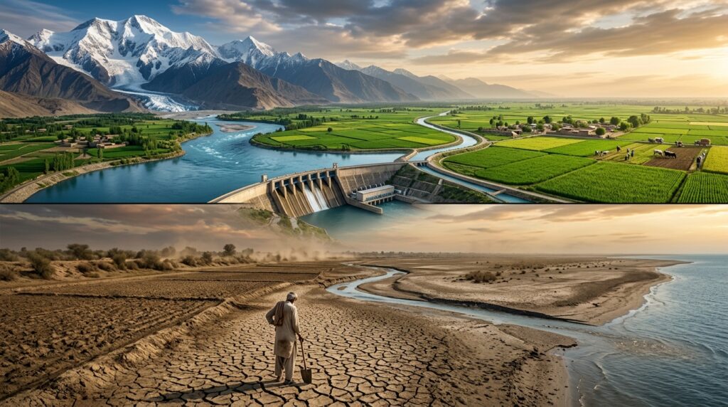
Can One Dam Create Pakistan’s Water Crisis?
This question appears frequently in political debates. The available scientific and engineering evidence suggests that the answer is no.
Most Indian hydropower projects on the western rivers are run-of-river facilities with limited storage compared with the enormous annual flow of the Indus Basin. Such projects may influence the timing of releases over shorter periods within their operational limits, but they are generally not capable of permanently withholding the full volume of water allocated to Pakistan under the treaty.
At the same time, Pakistan’s concerns about cumulative impacts, operational flexibility, design features and advance notification have formed the basis of repeated treaty proceedings and deserve careful technical examination. Equally important is recognising that Pakistan’s water challenges are influenced by multiple interacting factors, including climate variability, reservoir sedimentation, groundwater depletion, irrigation efficiency, population growth, governance and transboundary river management.
Reducing this complex issue to a single cause would not accurately reflect the evidence.
A Balanced Assessment
After examining the historical record, treaty text, engineering literature and international legal proceedings, several conclusions emerge.
What Is Well Established
The Indus Waters Treaty remains one of the most detailed international river agreements ever negotiated.
India possesses recognised treaty rights to specified uses of the western rivers, including run-of-river hydropower, subject to technical conditions.
Pakistan possesses recognised rights as the principal user of the western rivers and may challenge proposed projects through mechanisms established under the treaty. Hydropower disputes concerning Baglihar, Kishanganga and Ratle have generated extensive international legal and engineering review. Climate change is increasing uncertainty across the entire Indus Basin.
What Remains Disputed
Whether particular engineering features of certain projects fully comply with treaty provisions. The extent to which cumulative upstream infrastructure may influence downstream hydrology. The legal consequences of India’s decision to place the treaty in abeyance. The proper interpretation of several technical provisions in light of modern engineering practices.
Where More Research Is Needed
Long-term cumulative basin modelling.
Independent assessment of climate impacts on seasonal river flows.
Modernisation of hydrological data-sharing systems.
Joint flood forecasting and early-warning mechanisms.
Future treaty adaptation under changing climatic conditions.
Lessons for Pakistan
While international diplomacy remains essential, Pakistan’s long-term water security cannot depend exclusively on developments beyond its borders.
Several domestic priorities deserve equal attention:
Increasing national water storage capacity.
Modernising irrigation infrastructure.
Reducing water losses.
Improving groundwater regulation.
Expanding wastewater recycling.
Strengthening watershed management.
Investing in hydrological research and climate adaptation.
Enhancing institutional coordination.
A resilient Pakistan will require both effective diplomacy abroad and sound water governance at home.
Purpose of the Article
This article aims to provide readers with an evidence-based understanding of the Indus Basin, the Indus Waters Treaty, India’s upstream hydropower strategy, Pakistan’s legal concerns and the evolving framework of international water law. Its purpose is educational and analytical, helping readers distinguish between facts, competing legal interpretations and areas where further technical evidence remains necessary.
Editorial Policy (EP) Statement
This article is part of an independent research series on water security. It relies on treaty texts, international legal proceedings, official government documents, engineering literature and publications from recognised international organisations. Where disagreements exist between India and Pakistan, both positions are described and clearly distinguished from findings of international dispute-resolution bodies. The objective is to encourage informed, evidence-based discussion rather than advocacy or political rhetoric.
Frequently Asked Questions
1. Can India legally build dams on the western rivers?
Yes. The treaty permits specified uses, including run-of-river hydropower and limited storage, provided the projects comply with the treaty’s engineering and operational requirements. Disputes arise over whether particular projects satisfy those requirements.
2. Can India completely stop the flow of water to Pakistan?
Current engineering evidence indicates that existing run-of-river projects generally lack sufficient storage capacity to stop the full flow of the western rivers permanently. However, project operations, timing of releases and future infrastructure remain subjects of technical and legal debate.
3. Why are Baglihar, Kishanganga and Ratle controversial?
Pakistan has challenged aspects of their engineering design under the treaty. India maintains that the projects comply with its treaty rights. Different elements have been examined through Neutral Expert proceedings, Courts of Arbitration and other treaty mechanisms.
4. What is the World Bank’s role today?
The World Bank facilitates certain procedural aspects of the treaty, such as appointments under specified circumstances. It is not the treaty’s enforcement authority and does not decide compliance disputes.
5. Does climate change make the treaty less relevant?
No. If anything, climate change increases the importance of effective cooperation because river flows are becoming more variable and extreme events more frequent.
6. What is the greatest long-term challenge for Pakistan?
Most experts consider the greatest challenge to be the combination of climate change, population growth, groundwater depletion, limited storage, irrigation inefficiency and effective management of shared rivers rather than any single factor acting alone.
Selected References
- Indus Waters Treaty.
- World Bank, Fact Sheet: The Indus Waters Treaty and the Role of the World Bank. (Aceris Law)
- Permanent Court of Arbitration, public documents relating to the Indus Waters proceedings. (PCA-CPA)
- International Water Management Institute, research on the Indus Basin.
- Pakistan Council of Research in Water Resources, national water assessments.
- United Nations Educational, Scientific and Cultural Organization, United Nations World Water Development Report.
- Food and Agriculture Organization, AQUASTAT.
- International Commission on Large Dams, technical publications.
- Recent reporting and legal analysis on the treaty’s status and dispute proceedings. (AP News)